 The U.S. Geological Survey Hydrologic Benchmark Network
by Peter S. Murdoch, Michael R. McHale, M. Alisa Mast, and David W. Clow
U.S. GEOLOGICAL SURVEY
Fact Sheet 2005-3135
ABSTRACT
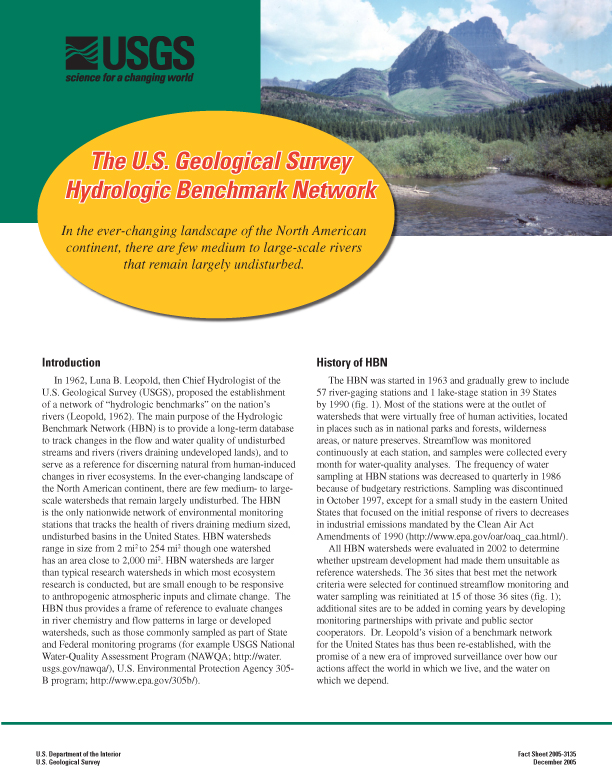
In 1962, Luna B. Leopold, then Chief Hydrologist
of the U.S. Geological Survey (USGS),
proposed the establishment of a network of 'hydrologic
benchmarks' on the nations rivers. The main purpose of the
Hydrologic Benchmark Network (HBN) is to provide a long-term
database to track changes in the flow and water quality of
undisturbed streams and rivers (rivers draining undeveloped
lands), and to serve as a reference for discerning natural
from human-induced changes in river ecosystems. In the
ever-changing landscape of the North American continent,
there are few medium- to large-scale watersheds that remain
largely undisturbed. The HBN is the only nationwide network
of environmental monitoring stations that tracks the health
of rivers draining medium sized, undisturbed basins in the
United States. HBN watersheds range in size from 2 mi2
to 254 mi2 though one watershed has an area close to
2,000 mi2. HBN watersheds are larger than typical research
watersheds in which most ecosystem research is conducted, but are
small enough to be responsive to anthropogenic atmospheric inputs
and climate change. The HBN thus provides a frame of reference
to evaluate changes in river chemistry and flow patterns in
large or developed watersheds, such as those commonly sampled
as part of State and Federal monitoring programs (for example,
USGS National Water-Quality Assessment Program [NAWQA];
U.S. Environmental Protection Agency 305-B program).
The HBN of 2005 has fewer stations than the original network of
Dr. Leopold, but modern sampling strategies and equipment allow
a far more detailed understanding of how the Nations streams
and rivers are changing than was feasible in the 1960s when
the HBN began. In 2003, 15 of the original HBN stations were
equipped with refrigerated, automated samplers and telemetry
systems that allow program coordinators to monitor stream
conditions and adjust sampling frequency and capture unique
stream conditions or special sampling needs. The automated
sampling system is designed to collect samples through a
wide range of flow conditions and to transmit data by satellite.
About 25 water samples are collected annually at each HBN
water-quality station and refrigerated on site until retrieved
by field personnel who visit the sites regularly. Flow-based
automatic sampling assures that samples are collected through
the range of flow conditions at each site during each season
of the year. Samples are analyzed for major anions and cations,
pH, dissolved organic carbon (DOC), dissolved organic nitrogen
(DON), acid neutralizing capacity (ANC), silica, and aluminum.
HBN basins are often used for investigations of local concern
that supplement HBN data collection, provide additional
water-quality data such as pathogens, pesticides, stable
isotopes, and phosphorus for periods of months to years,
and offers the opportunity to collaborate with other local,
State, and Federal agencies as well as academia and the
private sector. This flexible monitoring capability allows a
baseline of long-term data to be maintained while supporting
regional and national investigations of emerging environmental
issues.
Citation: Murdoch, P.S., McHale, M.R., Mast, M.A., and Clow, D.W., 2005, The U.S. Geological Survey Hydrologic Benchmark Network: U.S. Geological Survey Fact Sheet 2005-3135, 6 p., 4 figs.
 [Full Report, Acrobat PDF
(2.4M)]
[Full Report, Acrobat PDF
(2.4M)]
[an error occurred while processing this directive]
|