Evaluation of a barrier-island breach created by Hurricane Sandy at Fire Island National Seashore, N.Y.—Continued.
Measurement of water velocities and depths on November 13, 2013 — methods and results
Objective:
On November 6 and November 20, 2012, and June 26 and November 13, 2013, U.S. Geological Survey (USGS) New York Water Science Center (NYWSC) personnel collected data to evaluate channel geometry, water velocity, and discharge of an open breach in the Federal Wilderness area of Fire Island National Seashore, N.Y. The breach resulted from major coastal flooding and overwash created by Hurricane Sandy on October 29, 2012. Data were collected using a Sontek1 M9 Acoustic Doppler Current Profiler (ADCP) with Real-Time Kinematic (RTK) Global Positioning System (GPS). Data were processed into Geographic Information System (GIS) for interpolation and display. The following information generally summarizes the measurement of water velocities and depths within the Wilderness breach on November 13, 2013.
Approach:
An initial series of transects was collected starting about 2 hours before ocean low tide on November 13, 2013. Data were collected perpendicular to flow through the breach beginning at 0732 Eastern Standard Time (EST) and ending at 0805 EST. The first set of transects was taken near the bayward side of the breach, with subsequent sets collected progressively closer to the seaward side of the breach. Discharge ranged from 12,800 ft3/s (cubic feet per second) during the beginning set of transects to 15,500 ft3/s during the final set of transects.
A second series of transects was collected starting about 2 hours before ocean high tide on November 13, 2013. Data collection began at 1347 EST and ended at 1419 EST. The first set of transects was taken near the seaward side of the breach; subsequent sets were generally collected progressively closer to the bayward side of the breach. Discharge ranged from 12,400 ft3/s during the beginning set of transects to 18,500 ft3/s during the final set of transects.
Additional data were collected along the approximate centerline and adjacent to the shores of the channel, as well as perpendicular to the flood tidal channels bayward of the former Great South Bay (GSB) shoreline, to map the inundated area of the breach. The overall mapped area includes data collected during discharge measurements of both incoming and outgoing tide conditions. The Digital Elevation Model (DEM) was created by plotting the depths of all data points collected relative to North American Vertical Datum of 1988 (NAVD 88) and interpolating the elevation of the bathymetric surface between these points.
Collection of water levels within GSB adjacent to the breach is being be done with a modified USGS storm-tide sensor. This sensor, which normally collects 7 days of 30-second-interval data, has been reprogrammed to collect about 2 months of routine (6-minute-interval) tide-gage observations. Two sensors, an Onset1 HOBO and an In-Situ1 Aqua TROLL, were installed on September 9, 2013, to help ensure that at least one would remain fully operational through the planned, 2-month deployment. The East (HOBO) sensor was lost between September and October 2013 (based on aerial photographs from http://po.msrc.sunysb.edu/GSB/) when the portion of the dock on which it had been installed was washed away. The West (Aqua TROLL) sensor was recovered from its position on the end of the dock nearest to Pelican Island. Water level data from this sensor were corrected for instrument drift based on water-level elevations measured during deployment and recovery. This sensor also recorded water-temperature data. Sensor data can be viewed here (sensor deployment notes, West-sensor records for water level [plot, data] and temperature [plot, data]). The redeployed West (Aqua TROLL) sensor was lost between February and March 2014 when the remaining part of the dock washed away.
1Use of trade, product, or firm names is for descriptive purposes only and does not imply endorsement by the U.S. Government.
Available products:
<< 5 of 7 >>
|
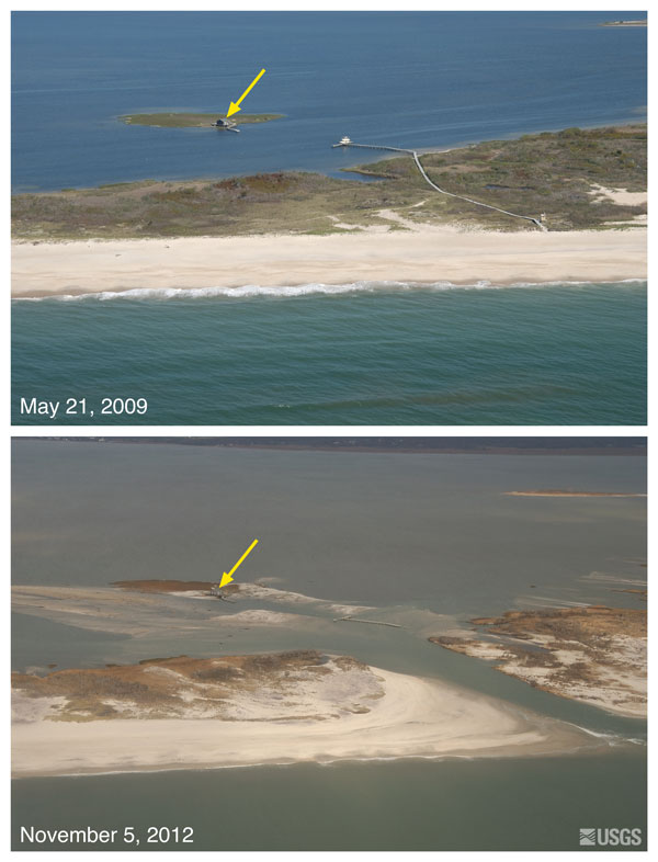
Aerial Photographs of Wilderness breach—Before & After Hurricane Sandy
Oblique aerial photographs of Pelican Island and Fire Island, New York. The
view is looking northwest across Fire Island towards Great South Bay. This
location
is within Fire Island National Seashore near Old Inlet—a very narrow
portion of the
island that has experienced breaching in previous large storms.
The island breached during
Hurricane Sandy, creating a new inlet. Despite the
breach, the fishing shack (yellow arrow) remained standing. Click on image to
enlarge.

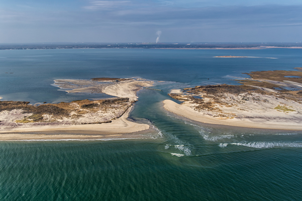
Aerial view of the Wilderness breach at Old Inlet, looking from the Atlantic Ocean
to Great South Bay, on Saturday, November 10, 2012. NPS Photo/Abell.

Related Links:
Hurricane Sandy Information
|